Rainfall and strong winds expected today. The frozen ground has a reduced ability to absorb this rainfall.
What:
Wind gusts of 60 to 80 km/h.
Total rainfall amounts of 10 to 20 mm.
When:
Now through this afternoon.
Additional information:
Showers with a risk of thunderstorms are expected.
South to southwest winds will strengthen ahead of the passage of a cold front this afternoon, resulting in gusts of 60 to 80 km/h at times.
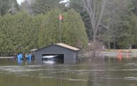
Localized flooding in low-lying areas and water pooling on roads are possible. Loose objects may be tossed by the wind and cause injury or damage. Utility outages may occur.
For information concerning flooding, please consult your local Conservation Authority or Ontario Ministry of Natural Resources office. Visit Ontario.ca/floods for the latest details.
###
Please continue to monitor alerts and forecasts issued by Environment Canada. To report severe weather, send an email to ONstorm@ec.gc.ca or post reports on X using #ONStorm.
Environment Canada says conditions are favourable for the development of severe thunderstorms across parts of Ontario this weekend.
A heavy band of rain clouds are moving in across southern Ontario this weekend, with some wind, and potential for thunderstorms.
Environment and Climate Change Canada has already issued a weather alert for parts of southwestern Ontario, and more alerts are expected to follow for southeastern regions.
“We are expecting rain and wind, and it’s going to progress west to east, starting in Windsor, Sarnia and moving east,” Environment Canada warning preparedness meteorologist Barbara Lapido said. “It’s going to be reaching the Ottawa region maybe Saturday night.”
For now, the expectation is to see between 20 to 40 millimetres of rainfall.
ARTICLE CONTINUES BELOW
As the storm tracks across the province, further weather alerts are expected for those in the GTA, Durham Region, Peterborough and Ottawa Valley.
“The lead time is 24 hours, so as those (storms) reach southwestern regions first, the other half will be issued a message tonight or tomorrow morning,” Lapido said. “The other half is the same.”
ARTICLE CONTINUES BELOW
Thunderstorms possible
ARTICLE CONTINUES BELOW
“We are expected some isolated thunderstorms with the system, so there may be some lightning,” she said.Â
Those thunderstorms are going to be accompanied by wind, with gusts from 60 to 80 km/h.
“We are not announcing thunderstorms in a special news statement. We are waiting for them to form, so people should keep an eye for local alerts,” she said.
But with the wind, Lapido said people should be aware not to leave loose objects outside, as there is potential for it to blow around.
With some milder temperatures and wind expected, Lapido was asked if any tornadoes are possible.
“So far, that’s not in the picture, but people should keep an eye on local warnings.”
ARTICLE CONTINUES BELOW
Warmer than normal for the weekend
As the rain clouds move across the area, the overall temperatures for Ontario are going to remain mild, between 10 and 15 C across the region.
“It’s pretty much going to be a windy, rainy, warm weekend,” Lapido said.
The warmer temperatures may help clear some of the snow, but there is a chance of localized flooding.
Lapido said to check with your local conservation authority, or at to see if any flood notifications are happening in your area.
Monday brings cooler temperatures
The weather conditions are expected to settle after Sunday night, however, it also means a dip in temperature.
ARTICLE CONTINUES BELOW
“The temperatures are going to decrease Sunday into Monday. We are talking about negative temperatures again — especially in the morning Monday. To come from a weekend of 10 degrees, it will be -1 or -2 C, and that can be significant for some people.”
With roads wet, it may freeze overnight, especially for those in the Ottawa Valley area, which may still have rain continuing early Monday morning.
Today's Headlines ş¬Đ߲ݴ«Ă˝letter
Get our free morning newsletter
Error! Sorry, there was an error processing your request.
There was a problem with the recaptcha. Please try again.
You may unsubscribe at any time. By signing up, you agree to our and . This site is protected by reCAPTCHA and the Google and apply.
Today's Headlines ş¬Đ߲ݴ«Ă˝letter
You're signed up! You'll start getting Today's Headlines in your inbox soon.
Want more of the latest from us? Sign up for more at our newsletter page.
is an award-winning journalist covering Simcoe County for more than 22 years. She is mom to two boys who are into sports and tech. She can be reached at JRamsay@simcoe.com. Follow Simcoe.com on X, formerly Twitter.
Your gift purchase was successful!Your purchase was successful, and you are now logged in. You will also start receiving our free morning newsletter soon.


To join the conversation set a first and last name in your user profile.
Sign in or register for free to join the Conversation